Sunday, August 1
We bid farewell to Peggy's Cove and head west.
We stopped for the night at Sebasticook Lake Campground in Newport, ME. This is a pleasant campground whose host, whom we rousted from her dinner, was quite gracious.
Monday, August 2
We stopped at My Cousin's Place in Norridgewock, ME, for breakfast. This small cafe by the side of the highway served up a huge and tasty breakfast. From there we headed across New Hampshire and into Vermont.
Our route took us through Waterbury, VT. Since both Green Mountain Coffee and Ben and Jerry's Ice Cream are located there, we stopped to have a look. Each was a bit of a disappointment. Green Mountain Coffee was really nothing more than a storefront - at least, that's what the public gets to see. Ben and Jerry's held more promise, but the crowds of people were off-putting. The factory tour would have been fun, but the hour-plus wait for a ticket was more than we were prepared to endure. Some of their famous ice cream would have been fun, but the half-hour long line to the serving window was, also, more that we wanted to take on. We did, however, enjoy the walk through the "Flavor Graveyard".
Bank on the road, we continued on US 2 north on Grand Isle in the middle of Lake Champlain. On Grand Isle we had to pull over and stop to wait out a ferocious rainstorm. It was a deluge, a downpour, a toad-strangler of the first order. We had to wait for a half-hour for the rain to let up so that the wipers could clear sufficient enough for us to see the road.
Our camp for the night was at Coles Creek State Park in New York on the St. Lawrence Seaway. This is a lovely campground. Nicely spaced sites and very, very clean facilities. Plus, if you're lucky - as we were, you can grab a site with a great view of the shipping traffic on the seaway. We recommend this state park.
Tuesday, August 3
We crossed the border at Ogdenberg, NY, into Ontario, Canada.
We stopped for the night at Chutes Provencial Park near Massey, Ontario. This is a nice park and has some trails that we would have liked to explore. But, it was just too danged HOT!
Wednesday, August 4
Finishing our trek across Ontario, we crossed back in to the US at Sault St. Marie. This time we spent only one hour and twenty minutes on the bridge from Canada to the US. This time we had the foresight to gas up and make a potty stop before getting on the bridge.
Our stop for this night was at Van Riper State Park in Michigan. This is another very nice park. The sites with hook-up were pretty full and we decided to park in the "rustic" area. A nice site and quiet. We'd like to stay at this park again and explore the part of the park to the north of the highway. There looks to be some scenic trails there.
Thursday, August 5
We return to our condo in Duluth. We collected seven thousand miles, hundreds of photos, and many, many memories of people and places.
That ends the tale of our trip to the East Coast.
Sunday, December 19, 2010

Tuesday, October 19, 2010
July 31, 2010 - Halifax, Nova Scotia
Saturday, July 31, 2010
This time it's a day trip from our campsite to Halifax, Nova Scotia.
View Peggy's Cove to Halifax in a larger map
Saturday dawned with a mix of sun and clouds and very pleasant (read, cool) temps. This will be our last day on the south coast of Nova Scotia and we decided it would be wrong to leave the area without visiting Halifax, even 'though large cities are not our favorite places to be.
Pictures for this day are here.
Our first impressions on arriving at Halifax were that the city combines the best of Duluth's hillside location with Boston's chaotic street plan and Chicago's "there-is-no-such-thing-as-a-too-small-parking-spot" parking culture. But, the sun was shining and we soldiered on to find easy parking in the huge lot that services the docks for the cruise ships. The lot was empty as there were no ships due in port that day.
At the parking lot we met FRED. FRED is a shuttle bus service for the downtown Halifax area. FRED stands for Free Rides Everywhere Downtown. FRED is a very nice fellow to have around. Our visit to Halifax was much more pleasant having met FRED.
Our first stop was the Maritime Museum of the Atlantic. This museum is worth the stop. We particularly enjoyed the Titanic exhibit. The museum exhibits include the CSS Acadia, the only ship still afloat that served the Royal Canadian Navy in both World Wars. I took several pictures of the harbor from the fantail of the Acadia.
We strolled the waterfront boardwalk with just a few thousand of our closest friends and stopped for a quick lunch of fish and chips. I had asked ticket-taker on the Acadia if the crowds were often this large. He said, "Nope. Actually this is a light day. When the cruise ships come in, then it gets crowded. Sometimes as many as five of them are in port at the same time. You should see this place then!" Thanks anyway. I think I'll pass.
Finished with the waterfront, we met up with FRED and he took us up the hill to the Citadel. The day was getting warm so Nancy stayed under shade while I explored the nooks and crannies of this large fort. Many college students were on duty portraying soldiers and other characters in period costume of the time of the Citadel's operation.
I was surprised when I came across a school room. The "teacher" told me that the school was for the enlisted men, not for children. The opportunity for an education was one of the draws for military service at the fort. According to the "teacher", many of the soldiers took advantage of the school to get an education.
Out on the parade ground, a squad of soldiers was practicing their drills. By this time, the day had turned hot and I felt sorry for the men in their woolen tunics marching in the blazing sun. Then they stopped and loaded their rifles. "This is going to be good!", I thought. I got myself to the front of the crowd in a place just ahead of the line of soldiers. "This'll be a great place for a picture!", I said to myself. It would have been, too, if I had used a tripod - and, maybe not even then. The blast of sound from the rifles was so strong that it shook everything in front of the line of rifles, even those of us off to the side.
As we waited at the entry to the Citadel for FRED to return, we got to witness the changing of the guard at the gate. This was one time on the trip that I wished I had a video camera.
FRED showed up and took us to the Public Gardens, where we relaxed for a while in th shade amidst the flowers. This gave me my final opportunity of the trip to take some flower pictures. After this respite, FRED took us back to our car and we bid "so long" to Halifax.
This was our last full day in Nova Scotia. On Sunday morning, the first of August, we broke camp and began our trek west, back to Minnesota.
This time it's a day trip from our campsite to Halifax, Nova Scotia.
View Peggy's Cove to Halifax in a larger map
Saturday dawned with a mix of sun and clouds and very pleasant (read, cool) temps. This will be our last day on the south coast of Nova Scotia and we decided it would be wrong to leave the area without visiting Halifax, even 'though large cities are not our favorite places to be.
Pictures for this day are here.
 |
| Halifax harbor |
Our first impressions on arriving at Halifax were that the city combines the best of Duluth's hillside location with Boston's chaotic street plan and Chicago's "there-is-no-such-thing-as-a-too-small-parking-spot" parking culture. But, the sun was shining and we soldiered on to find easy parking in the huge lot that services the docks for the cruise ships. The lot was empty as there were no ships due in port that day.
At the parking lot we met FRED. FRED is a shuttle bus service for the downtown Halifax area. FRED stands for Free Rides Everywhere Downtown. FRED is a very nice fellow to have around. Our visit to Halifax was much more pleasant having met FRED.
Our first stop was the Maritime Museum of the Atlantic. This museum is worth the stop. We particularly enjoyed the Titanic exhibit. The museum exhibits include the CSS Acadia, the only ship still afloat that served the Royal Canadian Navy in both World Wars. I took several pictures of the harbor from the fantail of the Acadia.
 |
| On the waterfront, Halifax, NS |
Finished with the waterfront, we met up with FRED and he took us up the hill to the Citadel. The day was getting warm so Nancy stayed under shade while I explored the nooks and crannies of this large fort. Many college students were on duty portraying soldiers and other characters in period costume of the time of the Citadel's operation.
 |
| The Citadel |
I was surprised when I came across a school room. The "teacher" told me that the school was for the enlisted men, not for children. The opportunity for an education was one of the draws for military service at the fort. According to the "teacher", many of the soldiers took advantage of the school to get an education.
Out on the parade ground, a squad of soldiers was practicing their drills. By this time, the day had turned hot and I felt sorry for the men in their woolen tunics marching in the blazing sun. Then they stopped and loaded their rifles. "This is going to be good!", I thought. I got myself to the front of the crowd in a place just ahead of the line of soldiers. "This'll be a great place for a picture!", I said to myself. It would have been, too, if I had used a tripod - and, maybe not even then. The blast of sound from the rifles was so strong that it shook everything in front of the line of rifles, even those of us off to the side.
 |
| Meeting FRED |
As we waited at the entry to the Citadel for FRED to return, we got to witness the changing of the guard at the gate. This was one time on the trip that I wished I had a video camera.
FRED showed up and took us to the Public Gardens, where we relaxed for a while in th shade amidst the flowers. This gave me my final opportunity of the trip to take some flower pictures. After this respite, FRED took us back to our car and we bid "so long" to Halifax.
This was our last full day in Nova Scotia. On Sunday morning, the first of August, we broke camp and began our trek west, back to Minnesota.
 |
| Farewell to Peggy's Cove |
Monday, October 18, 2010
July 30, 2010 - Day Trip to Lunenburg
Friday, July 30, 2010
A day trip to Lunenburg, Nova Scotia.
View Peggy's Cove to Lunenburg in a larger map
Pictures from this day are here.
Before our day trip to Lunenburg we headed to Peggy's Cove to explore it a bit more before the tour buses started showing up. The granite ledge that holds the lighthouse as well as the large restaurant and huge parking lot is massive. Trying to show the scale of the rock in a photograph is an exercise in futility, but that didn't stop me from trying. The sun was shining weakly through high, thin clouds and from just the right angle it created a halo around the top of the lighthouse.
Just up the road from Peggy's Cove, we stopped at the Swissair Flight 111 Memorial.
To get to Lunenburg, we took roads as close to the coastline as we could get. There are many, many quiet and picturesque bays and harbors and coves. Not the grand vistas of Cabot Trail around Cape Breton Island, instead we were treated to intimate postcard scenes around each bend in the road.
Lunenburg has many houses and other buildings from the 1700s and early 1800s that are still in use today. Most of them are brightly painted in color schemes that we just don't see in the upper midwest. Lunenburg is a great town to get out of the car and just wander around the streets. Check out this fun website to explore these colorful buildings on an interactive map.
We had a great time taking pictures of various houses and buildings. We got to only a small percentage of them.
Returning from Lunenburg, we stopped for dinner in the small community of Chester, Nova Scotia. On the recommendation of the proprietor of the Delish Deli and Cafe we dined at the Kiwi Cafe. Fred had to try the lobster spaghetti. He was glad he did.
We got back to Peggy's Cove in time to enjoy clear skies and a lovely sunset. A perfect end to the day.
A day trip to Lunenburg, Nova Scotia.
View Peggy's Cove to Lunenburg in a larger map
 |
| Early sun behind the light |
Before our day trip to Lunenburg we headed to Peggy's Cove to explore it a bit more before the tour buses started showing up. The granite ledge that holds the lighthouse as well as the large restaurant and huge parking lot is massive. Trying to show the scale of the rock in a photograph is an exercise in futility, but that didn't stop me from trying. The sun was shining weakly through high, thin clouds and from just the right angle it created a halo around the top of the lighthouse.
Just up the road from Peggy's Cove, we stopped at the Swissair Flight 111 Memorial.
To get to Lunenburg, we took roads as close to the coastline as we could get. There are many, many quiet and picturesque bays and harbors and coves. Not the grand vistas of Cabot Trail around Cape Breton Island, instead we were treated to intimate postcard scenes around each bend in the road.
 |
| Lunenburg waterfront |
We had a great time taking pictures of various houses and buildings. We got to only a small percentage of them.
 |
| Sunset at Peggy's Cove |
Returning from Lunenburg, we stopped for dinner in the small community of Chester, Nova Scotia. On the recommendation of the proprietor of the Delish Deli and Cafe we dined at the Kiwi Cafe. Fred had to try the lobster spaghetti. He was glad he did.
We got back to Peggy's Cove in time to enjoy clear skies and a lovely sunset. A perfect end to the day.
July 29, 2010 - Peggy's Cove, Nova Scotia
Thursday, July 29, 2010 - Peggy's Cove, Nova Scotia
We made it! A major goal of the trip was to get to Peggy's Cove.
View Hilden to Peggy's Cove in a larger map
We drove south from the Scotia Pine Campground to the King Neptune Campground at Indian Harbor, set up the Scamp and headed Peggy's Cove.
The landscapes in this area are a mixture of huge granite boulders scattered among marshy wetlands and potholes, pink granite outcrops capped with stunted evergreens, and long shoreline vistas uninterrupted by the low-growing rushes and sedges. As we drove though them, the views reminded us of similar scenes from the Lofoten Islands in the north of Norway, and some of the rugged areas in the Boundary Waters Wilderness Canoe Area, and, surprisingly, Weathertop from Lord of the Rings.
It was a cloudy, foggy morning and it was perfect for our introduction to the cove. Of course, a bright and clear day would have been perfect as well.
Peggy's Cove is a jewel. A delight for an artist or a photographer or a casual tourist; actually, anyone lucky enough to have eyes that see. Pictures submitted as totally inadequate proof of that statement are presented here.
Working boats at docks nestled in a tiny harbor surrounded by weathered boat houses. Old dories and launches pulled up at the water's edge. Fishermen's houses scattered like toys across the granite shore. Peggy's Cove is one of those places that invite you to spend a day or a lifetime trying to capture its essence on canvas or film.
Peggy's Cove is not far from the big city of Halifax, Nova Scotia. As you might guess, it is a very popular tourist destination. Dozens of large tour buses descend daily on Peggy's Cove, disgorging hundreds of camera-wielding tourists. (I should talk, right?) Peggy's Cove is best experienced, in my opinion, early in the day before the buses arrive, or late in the day nearing sunset after the buses depart, or in inclement weather such as fog and rain which imparts a more intimate feel to the place.
Needing to restock our food and cash supplies, we headed up the road to the shopping center at Tantallon. On the return, we stopped at the White Sails Bakery on the shore of St. Margarets Bay where we bought our first bag of oat cakes and we found them to be a very tasty treat. The Delish Deli and Cafe is on the second floor of the building that houses the bakery.
For lunch at the deli, Nancy sampled the "genuine Cornish" pasty which was very good but we like the smoked brisket pasties from Turtle River Pasties more, and a sausage roll. Fred bravely ordered the steak and kidney pie which he enjoyed - more than he thought he might.
Rain began to fall as we returned to our campsite. We spent the remainder of the day in the Scamp, resting and reading.
We made it! A major goal of the trip was to get to Peggy's Cove.
View Hilden to Peggy's Cove in a larger map
 |
| Set up at King Neptune Campground |
The landscapes in this area are a mixture of huge granite boulders scattered among marshy wetlands and potholes, pink granite outcrops capped with stunted evergreens, and long shoreline vistas uninterrupted by the low-growing rushes and sedges. As we drove though them, the views reminded us of similar scenes from the Lofoten Islands in the north of Norway, and some of the rugged areas in the Boundary Waters Wilderness Canoe Area, and, surprisingly, Weathertop from Lord of the Rings.
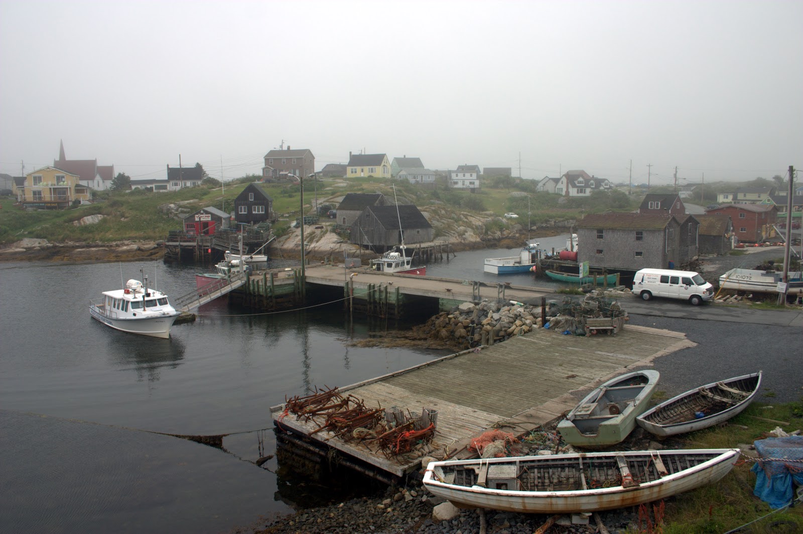 |
| Peggy's Cove |
Peggy's Cove is a jewel. A delight for an artist or a photographer or a casual tourist; actually, anyone lucky enough to have eyes that see. Pictures submitted as totally inadequate proof of that statement are presented here.
Working boats at docks nestled in a tiny harbor surrounded by weathered boat houses. Old dories and launches pulled up at the water's edge. Fishermen's houses scattered like toys across the granite shore. Peggy's Cove is one of those places that invite you to spend a day or a lifetime trying to capture its essence on canvas or film.
 |
| Docks at Peggy's Cove |
Needing to restock our food and cash supplies, we headed up the road to the shopping center at Tantallon. On the return, we stopped at the White Sails Bakery on the shore of St. Margarets Bay where we bought our first bag of oat cakes and we found them to be a very tasty treat. The Delish Deli and Cafe is on the second floor of the building that houses the bakery.
For lunch at the deli, Nancy sampled the "genuine Cornish" pasty which was very good but we like the smoked brisket pasties from Turtle River Pasties more, and a sausage roll. Fred bravely ordered the steak and kidney pie which he enjoyed - more than he thought he might.
Rain began to fall as we returned to our campsite. We spent the remainder of the day in the Scamp, resting and reading.
Sunday, October 17, 2010
July 28, 2010 - Leaving Cape Breton Island
Wednesday, July 28, 2010
We hooked up the Scamp and headed toward the eastern coast of Cape Breton Island. Although we didn't want to leave this scenic area, we did want to start making our way to Peggy's Cove.
View MacIntosh Brook to Hilden, Nove Scotia in a larger map
Moments after leaving the campground we came across a thatch-roofed stone hut at the side of the road. We pulled in to the parking area to explore. The stone hut is a replic of a Scottish Highlands crofter's shieling. A croft is an enclosed or fenced area of land, usually small, and a crofter is the person who has the right to use that area. The shieling served as a very rustic shelter for the crofter and the animals he was tending.
Photos of the shieling and other stops along the way are here.
 As we head across the northern part of Cape Breton Island, the road angles northeast along a very straight and deep valley between North Mountain and South Mountain. As the road begins the steep descent to the mouth of the valley and the coast, there are several signs warning of steep inclines and to use lower gears and to check brakes. Advice one would do well to heed! Luckily, there are several turnouts and overlooks where we could pull over to rest both ourselves and the rig.
At one pullout, a mini-van was already there with smoke coming from underneath. Smoke and a very pungent smell. We went over to see if there was a problem (as if the smell of burning brakes didn't give it away) and if we could offer assistance. The older woman and her two daughters said that they were just letting their car cool down before continuing on. They said that they were surprised at how steep the road was and how they had to ride the brakes the whole time! I asked if they hadn't noticed the signs saying to shift to a lower gear. They said that, yes, they'd seen the signs but "That's just for the trucks, isn't it?" We suggested that, while they still had some brake lining left, to use their second gear and apply the brakes as needed to keep the engine from over-revving and then have the brakes checked at the first opportunity. They left the pullout before we did. We did not see them again. One hopes for the best.
At the coast, we stopped for a picture break at Neils Harbor. Piled along the breakwater were very large stone slabs clamped in stout wooden "holders" with ropes attached. The only explanation we could come up with is that they are weights for buoys or nets. They were surely meant to be semi-permanent as hauling them up once they were set would be a back-breaking task.
Another picture stop was Green Cove, a large projection of pink granite into the sea. The granite here was veined with a lighter, harder rock that made interesting patterns. Green Cove has the notation "My favorite!" in Nancy's log.
Along the way, we pulled into Broad Cove Campground to check it out. It is a very nice place, run by the Canadian park service, and would be a good place to set up for a few days while exploring the Cape Breton Highlands in more detail.
At Port Hastings, we once again crossed the Canso Causeway and bid farewell to Cape Breton Island. Now, we were headed to the "heart" of Nova Scotia on our way to the province's southern coast. It was too far to make in one day's drive. We stopped for the night at Scotia Pine Campground near the small town of Hilden just south of the city of Truro.
On the morrow, we head to Peggy's Cove. It's worth the drive!
We hooked up the Scamp and headed toward the eastern coast of Cape Breton Island. Although we didn't want to leave this scenic area, we did want to start making our way to Peggy's Cove.
View MacIntosh Brook to Hilden, Nove Scotia in a larger map
 |
| Lone Shieling |
Photos of the shieling and other stops along the way are here.

At one pullout, a mini-van was already there with smoke coming from underneath. Smoke and a very pungent smell. We went over to see if there was a problem (as if the smell of burning brakes didn't give it away) and if we could offer assistance. The older woman and her two daughters said that they were just letting their car cool down before continuing on. They said that they were surprised at how steep the road was and how they had to ride the brakes the whole time! I asked if they hadn't noticed the signs saying to shift to a lower gear. They said that, yes, they'd seen the signs but "That's just for the trucks, isn't it?" We suggested that, while they still had some brake lining left, to use their second gear and apply the brakes as needed to keep the engine from over-revving and then have the brakes checked at the first opportunity. They left the pullout before we did. We did not see them again. One hopes for the best.
 |
| Neils Harbor |
At the coast, we stopped for a picture break at Neils Harbor. Piled along the breakwater were very large stone slabs clamped in stout wooden "holders" with ropes attached. The only explanation we could come up with is that they are weights for buoys or nets. They were surely meant to be semi-permanent as hauling them up once they were set would be a back-breaking task.
 |
| Buoy weights? |
Another picture stop was Green Cove, a large projection of pink granite into the sea. The granite here was veined with a lighter, harder rock that made interesting patterns. Green Cove has the notation "My favorite!" in Nancy's log.
Along the way, we pulled into Broad Cove Campground to check it out. It is a very nice place, run by the Canadian park service, and would be a good place to set up for a few days while exploring the Cape Breton Highlands in more detail.
 |
| Green Cove Rocks |
At Port Hastings, we once again crossed the Canso Causeway and bid farewell to Cape Breton Island. Now, we were headed to the "heart" of Nova Scotia on our way to the province's southern coast. It was too far to make in one day's drive. We stopped for the night at Scotia Pine Campground near the small town of Hilden just south of the city of Truro.
On the morrow, we head to Peggy's Cove. It's worth the drive!
Tuesday, October 12, 2010
July 27 - Havre Boucher to MacIntosh Brook Campground, Cape Breton
July 27, 2010
Today we started our tour of Cape Breton Island. We followed the Cabot Trail from the Canso Causeway, which links Cape Breton Island to the rest of Nova Scotia.
View Havre Boucher to Cape Breton in a larger map
Photos are here.
As we drove the beginning of the Cabot Trail, we enjoyed the road signs which were in English and Gaelic. In the rest of Canada, the road signs are in English and French, at least in the parts where we had traveled. When the signs use Gaelic, larger signs are needed to contain all the letters in the Gaelic words. They have an amazing number of consonants!

We stopped at the Glenora Distillery, North America's only single malt whiskey producer, which sits in a picturesque valley along the Cabot Trail. We considered taking the distillery tour, but it was a bit too pricey and didn't even include free samples.
Just up the road from the distillery, we stopped to take some pictures of the coastal towns of Margaree Harbour and Belle Cote. The road hugs the coast and provides magnificent views of the Gulf of St. Lawrence. This is, really, a gorgeous drive. Each overlook, and there are many, is worth a stop.
We stopped for lunch at the Acadian Restaurant in Cheticamp. Nancy had the chicken fricot and I had the meat pie. The fricot was tasty, but much different than our first fricot at Cap-Pele. It did confirm, however, that we are going to try to make our own fricot when we get home. The meat pie was good, too, with seasonings that are different than we find in the midwest.

Back on the road, we stopped at a nature walk through a slope fen. We would call it a bog, but it is on a slight slope and it is a fen, so "slope fen" it is. This gave me a chance to take a few flower pictures, and none too soon as "flower-picture-withdrawal" was starting to set in and that isn't pretty.
Our campsite for the night was a very small campground at MacIntosh Brook in the Cape Breton Highlands National Park.
Today we started our tour of Cape Breton Island. We followed the Cabot Trail from the Canso Causeway, which links Cape Breton Island to the rest of Nova Scotia.
View Havre Boucher to Cape Breton in a larger map
Photos are here.
As we drove the beginning of the Cabot Trail, we enjoyed the road signs which were in English and Gaelic. In the rest of Canada, the road signs are in English and French, at least in the parts where we had traveled. When the signs use Gaelic, larger signs are needed to contain all the letters in the Gaelic words. They have an amazing number of consonants!

We stopped at the Glenora Distillery, North America's only single malt whiskey producer, which sits in a picturesque valley along the Cabot Trail. We considered taking the distillery tour, but it was a bit too pricey and didn't even include free samples.
Just up the road from the distillery, we stopped to take some pictures of the coastal towns of Margaree Harbour and Belle Cote. The road hugs the coast and provides magnificent views of the Gulf of St. Lawrence. This is, really, a gorgeous drive. Each overlook, and there are many, is worth a stop.
We stopped for lunch at the Acadian Restaurant in Cheticamp. Nancy had the chicken fricot and I had the meat pie. The fricot was tasty, but much different than our first fricot at Cap-Pele. It did confirm, however, that we are going to try to make our own fricot when we get home. The meat pie was good, too, with seasonings that are different than we find in the midwest.

Back on the road, we stopped at a nature walk through a slope fen. We would call it a bog, but it is on a slight slope and it is a fen, so "slope fen" it is. This gave me a chance to take a few flower pictures, and none too soon as "flower-picture-withdrawal" was starting to set in and that isn't pretty.
Our campsite for the night was a very small campground at MacIntosh Brook in the Cape Breton Highlands National Park.
Thursday, October 7, 2010
July 26 - Murray Beach to Nova Scotia
Monday, July 26, 2010
We leave the provincial park and follow the shore of the Northumberland Strait to Nova Scotia.
No map this time. Google Maps refuses to let me get a map completed. Maybe next time...
Just before leaving New Brunswick soil, on a small rural backroad, we came upon the Winegarden Estate winery. Winegarden Estate was the first fruit wine-distillery in Atlantic Canada. They make a wide variety of products, ranging from fruit and grape wines to brandies and liqueurs and eau-de-vie. We enjoyed browsing all the different offerings and sampling a couple of them. Now, I wish I'd had the courage to buy a bottle of their apple liqueur or blueberry liqueur. Maybe next time...
We continued on the small coastal roads into Nova Scotia. Passing through New Glasgow and Antigonish we made it as far as Harve Boucher before deciding to call it a night. We found a campsite at the Hyclass Ocean Campground on the shore of St. Georges Bay.
No pictures for this day.
We leave the provincial park and follow the shore of the Northumberland Strait to Nova Scotia.
No map this time. Google Maps refuses to let me get a map completed. Maybe next time...
Just before leaving New Brunswick soil, on a small rural backroad, we came upon the Winegarden Estate winery. Winegarden Estate was the first fruit wine-distillery in Atlantic Canada. They make a wide variety of products, ranging from fruit and grape wines to brandies and liqueurs and eau-de-vie. We enjoyed browsing all the different offerings and sampling a couple of them. Now, I wish I'd had the courage to buy a bottle of their apple liqueur or blueberry liqueur. Maybe next time...
We continued on the small coastal roads into Nova Scotia. Passing through New Glasgow and Antigonish we made it as far as Harve Boucher before deciding to call it a night. We found a campsite at the Hyclass Ocean Campground on the shore of St. Georges Bay.
No pictures for this day.
Subscribe to:
Posts (Atom)